
Map of Zimbabwe | Google Maps | Expert Africa
See Zimbabwe in different ways, with different styles of maps.
Click on the buttons below.
Our map of Zimbabwe
This a sketch map of Zimbabwe – showing its key road arteries, national parks, towns, and areas of interest for visitors.
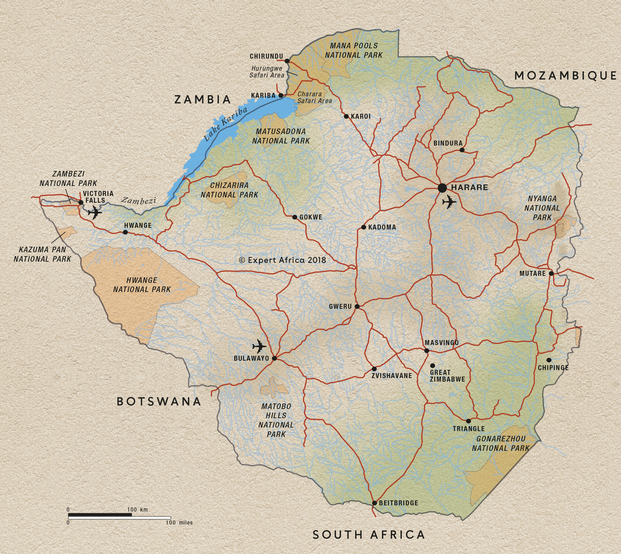
Google map of Zimbabwe
This map splits the main safari and holiday areas of Zimbabwe into ten parts. Read more about them by clicking the blue markers. Our more detailed maps of the areas show where there are different safari camps and lodges; to see these, follow links in the bubbles – or at the bottom of the page.
Our top safaris in Zimbabwe
Here are 15 great Zimbabwe safaris to inspire you.
Nyala Safari
10 days • 3 locations
VICTORIA FALLS AIRPORT TO VICTORIA FALLS AIRPORT
A superb luxury safari in iconic Hwange and Mana Pools national parks, staying in a pair of the finest safari camps in Zimbabwe, with a grand finale at Victoria Falls
US$10,150 - US$15,050 per person
Ground Hornbill Safari
9 days • 3 locations
VICTORIA FALLS AIRPORT TO BULAWAYO AIRPORT
This Zimbabwean odyssey explores Hwange National Park from two small camps, renowned for their great guiding, before ending with insights into cultural history, a little luxury and first-class rhino tracking in the Matobo Hills.
US$5,270 - US$8,560 per person
Grysbok Safari
9 days • 3 locations
VICTORIA FALLS AIRPORT TO HARARE AIRPORT
Discover three of Zimbabwe’s iconic destinations in style, flying between Hwange, Mana Pools and Lake Kariba on this varied safari adventure staying at authentic yet luxurious camps.
US$8,990 - US$14,380 per person

Buffalo Safari
9 days • 3 locations
HARARE AIRPORT TO VICTORIA FALLS AIRPORT
Combining Zimbabwe’s Mana Pools and Hwange national parks with stays at intimate six-tent safari camps offering excellent walking, canoeing and game drives. Superb wildlife viewing and a real wilderness-focused experience.
US$8,040 - US$11,910 per person

Pied Kingfisher Safari
9 days • 3 locations
VICTORIA FALLS AIRPORT TO HARARE AIRPORT
A luxury safari combining three of Zimbabwe's top highlights. The trip uses some of the finest safari camps in Zimbabwe and is perfect for a family or small group.
US$7,000 - US$10,780 per person

Klipspringer Safari
8 days • 3 locations
VICTORIA FALLS AIRPORT TO BULAWAYO AIRPORT
An outstanding-value Zimbabwe safari exploring Victoria Falls and two contrasting locations in western Zimbabwe – Hwange and the Matobo Hills – giving you a real feel for Zimbabwe, its people and wildlife.
US$2,890 - US$3,570 per person
Lion Safari
7 days • 2 locations
VICTORIA FALLS AIRPORT TO VICTORIA FALLS AIRPORT
The classic Expert Africa Zimbabwe safari. Combining two of our favourite independent camps, each run by celebrated guides, exciting game drives, world-class walks and canoeing in premier wildlife watching destinations.
US$6,950 - US$9,830 per person

Bat Hawk Safari
7 days • 2 locations
HARARE AIRPORT TO JOHANNESBURG AIRPORT
Explore two areas revered by safari enthusiasts with some of Africa’s best walking and some superb guiding – even by Zimbabwe’s high standards – for a varied and wonderfully immersive wilderness experience.
US$7,880 - US$9,130 per person

Great Egret Safari
12 days • 4 locations
MAUN AIRPORT TO VICTORIA FALLS AIRPORT
A wonderfully varied adventure to Botswana and Zimbabwe combining three fantastic safari areas, a luxury river cruise and the mighty Victoria Falls.
US$9,180 - US$17,080 per person
Side-striped Jackal Safari
6 days • 2 locations
VICTORIA FALLS AIRPORT TO VICTORIA FALLS AIRPORT
Get an in-depth experience of Zimbabwe’s colossal Hwange National Park, staying at two experience-focused camps with excellent guiding in contrasting areas. An adventurous safari for the real enthusiast.
US$3,480 - US$5,460 per person
Zimbabwe fact file
Useful information to help you prepare for your trip in Zimbabwe

Flights to Zimbabwe
How to get there & on to local destinations

LGBT Zimbabwe
Attitudes, the law & our experiences

Tipping in Zimbabwe
Expectations & guidelines for tipping

Zimbabwe general info
Essential travel information

Zimbabwe safari guides
Exceptional quality and value

Zimbabwe: is it ethical?
Background & our purpose
Weather & climate
The best time to visit Zimbabwe
