About Greystoke Mahale
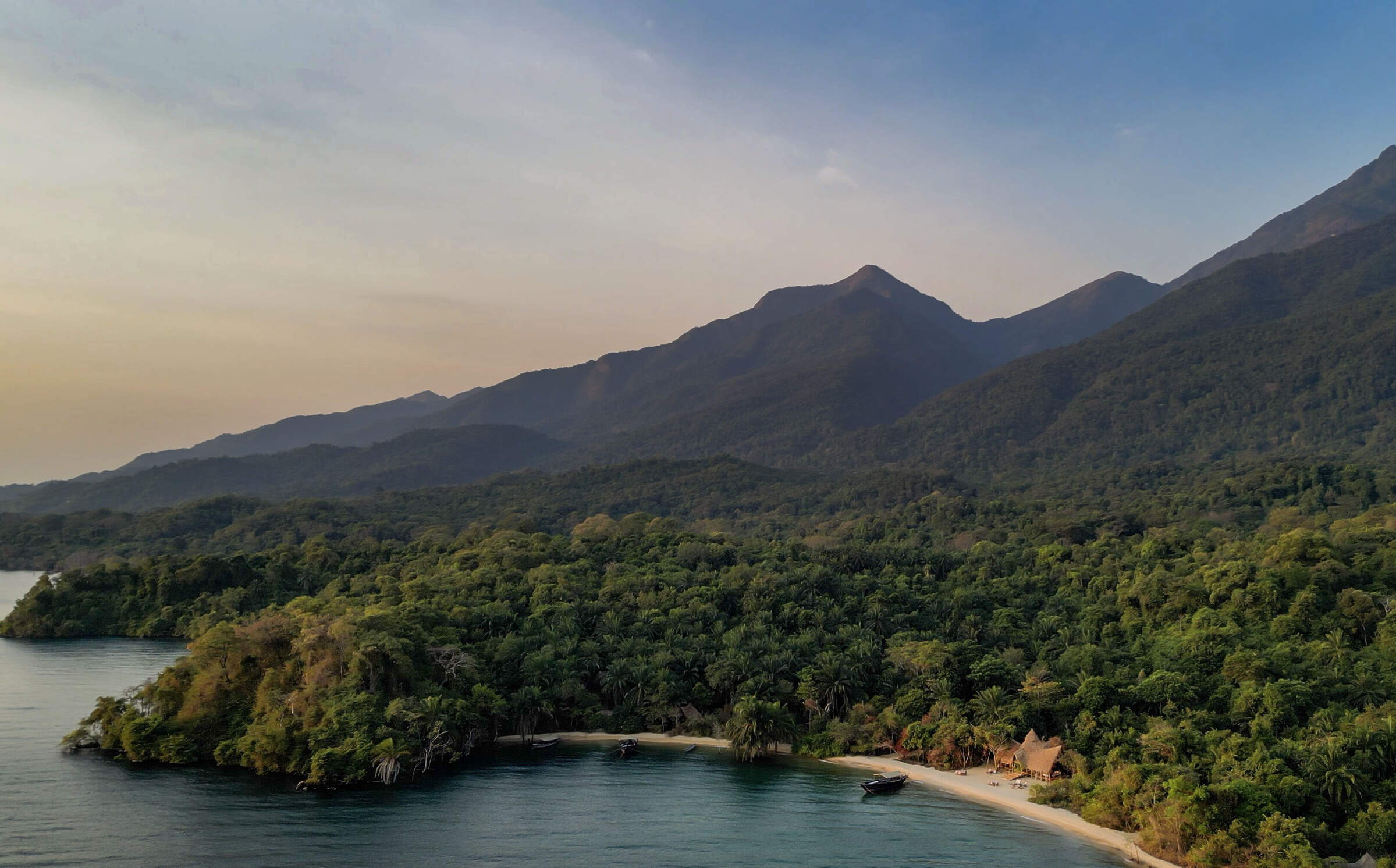
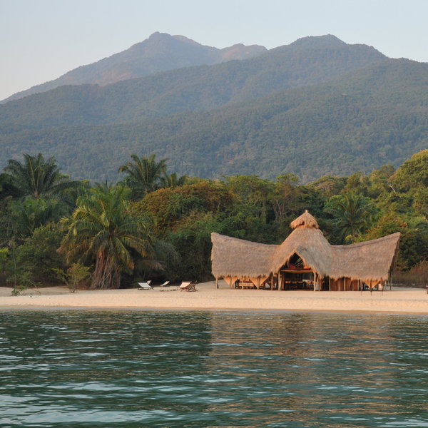
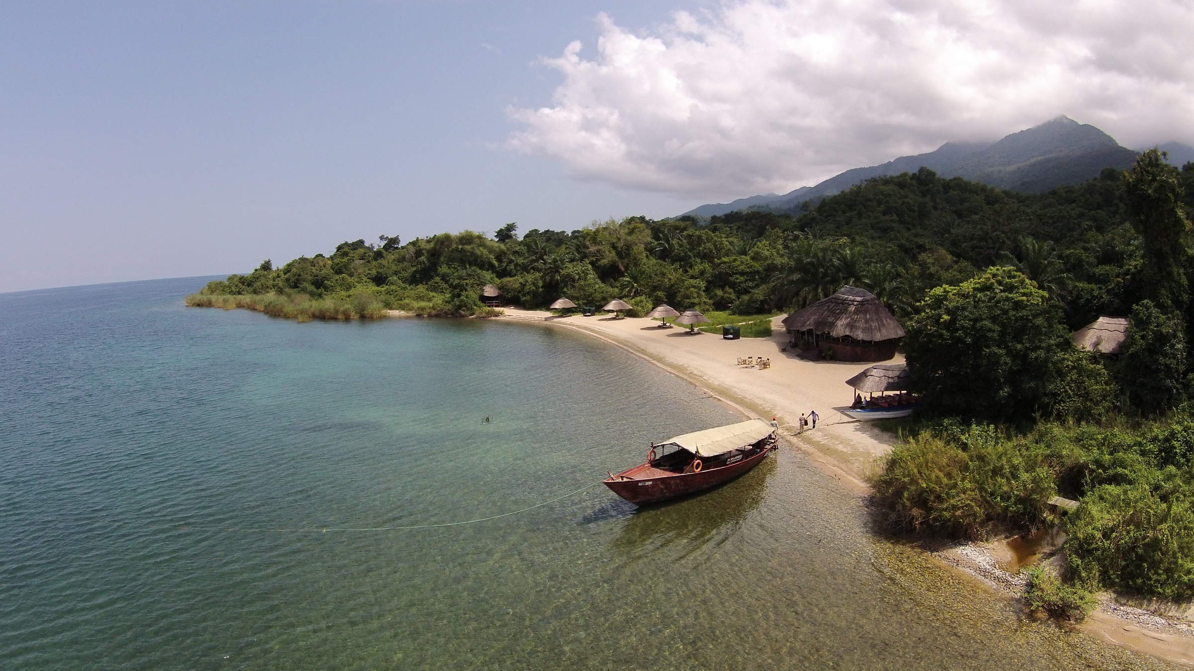
Greystoke Mahale is a unique, high-end camp that sits on a white-sand beach overlooking Lake Tanganyika's ...
... clear waters inside the remote Mahale Mountains National Park. The lodge is named after the legend of Tarzan and much of the experience here revolves around life in the forest, particularly chimpanzee-tracking.
Mahale Mountain National Park is one of the most remote and most beautiful parks in Tanzania - if not Africa - and Greystoke Mahale is definitely the best camp in the park. The chimpanzee experience is incredible, the afternoon boat rides relaxing, and the camp itself is beautifully constructed and very well run. The knowledge and personalities of the camp's guides are unbelievable; they add so much to the whole experience. For those who aren't afraid to go off the beaten track, and have the budget to stretch, you won't be disappointed by a trip here. Greystoke Mahale is a very special place.
Our view
Mahale Mountain National Park is one of the most remote and most beautiful parks in Tanzania - if not Africa - and Greystoke Mahale is definitely the best camp in the park. The chimpanzee experience is incredible, the afternoon boat rides relaxing, and the camp itself is beautifully constructed and very well run. The knowledge and personalities of the camp's guides are unbelievable; they add so much to the whole experience. For those who aren't afraid to go off the beaten track, and have the budget to stretch, you won't be disappointed by a trip here. Greystoke Mahale is a very special place.
Tanzania expert
Accommodation
6 bandas
Children
Recommended for 15+
Open
1st June–16th March
Activities

Birdwatching

Boat trip

Fishing

Guided walking safari

Kayaking

Primate trekking

Private activities
Traveller reviews of Greystoke Mahale
47 real, un-edited reviews from Expert Africa's travellers.


Expert Africa's gallery
When we travel we take lots of photos ourselves to give you a real and un-edited view of the safaris. See our 45 pictures and 3 videos of Greystoke Mahale to get the candid view.
View gallerySafaris visiting Greystoke Mahale
Just ideas, we'll always tailor-make a trip for you
Chimpanzee Fly-in Safari
8 days • 3 locations • 1 country
KILIMANJARO AIRPORT TO KILIMANJARO AIRPORT
Combining two of the remotest parks in Tanzania, this safari can deliver extraordinary wildlife viewing in Katavi, and East Africa's best chimp treks, on the shores of Lake Tanganyika.
Visiting Mahale Mountains, Katavi and 1 other area
US$13,190 - US$16,530 per person
Greystoke Mahale: Our full report
Greystoke Mahale is a unique, high-end camp that sits on a white-sand beach overlooking Lake Tanganyika's ...
... clear waters inside the remote Mahale Mountains National Park. The lodge is named after the legend of Tarzan and much of the experience here revolves around life in the forest, particularly chimpanzee-tracking.
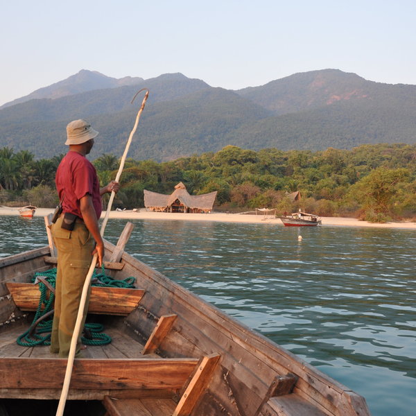
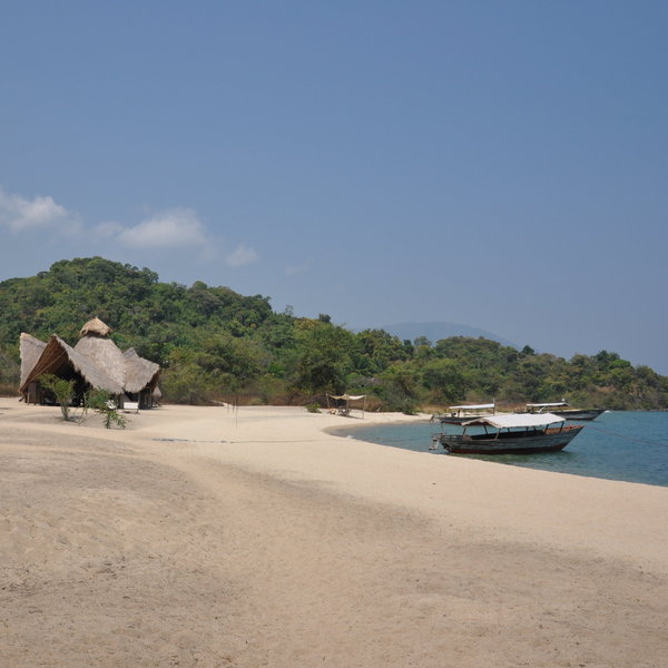
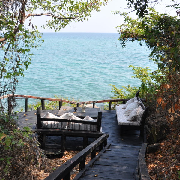
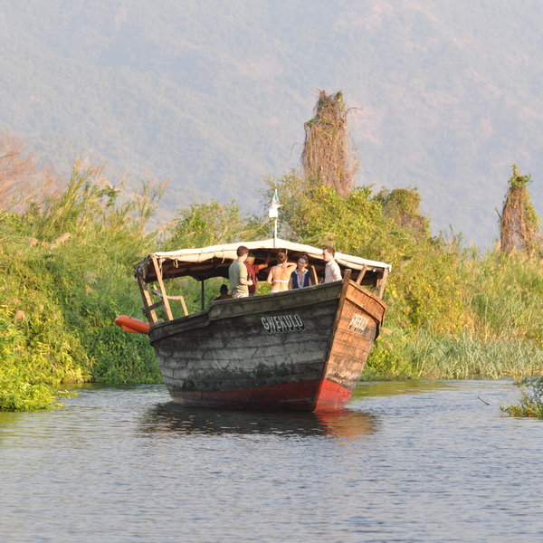
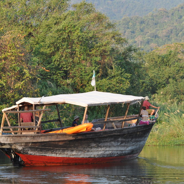
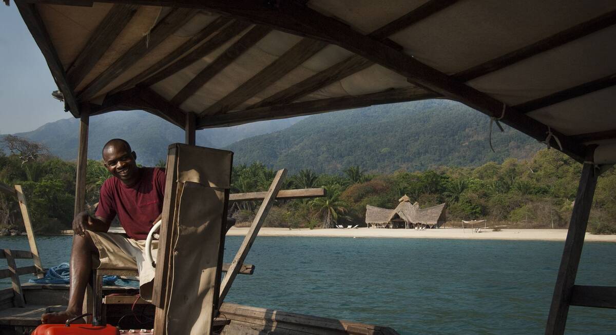
The adventure starts on the journey to Greystoke: after flying to Mahale (about five hours from Arusha, or 40 minutes from Katavi), you'll be greeted by smiling camp staff and escorted to the camp's large, wooden dhow for the final leg of your journey. During the ride, you'll be introduced to the area, the park and the lodge by one of the guides, and also have a light lunch (depending on the time of day). An hour or so later, as you sail along the beautiful coastline of Mahale National Park, you'll see the unmistakable thatched roof of Greystoke's main lodge emerge on the beach with the forested Mahale Mountains towering behind.
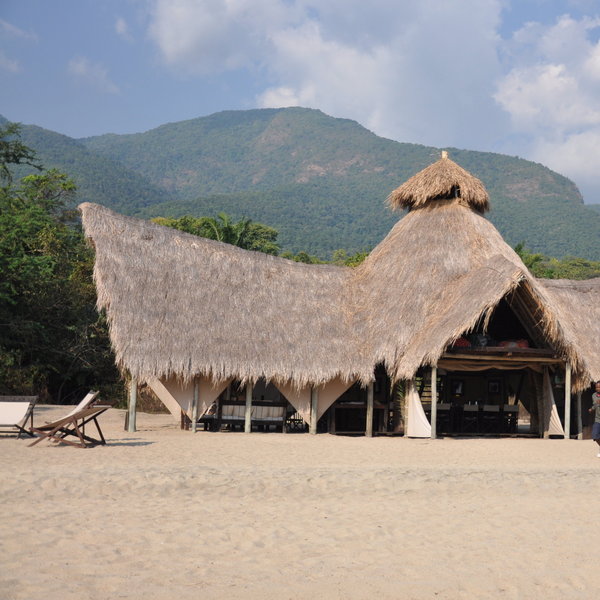
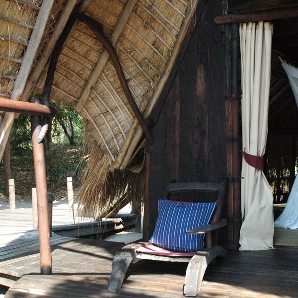
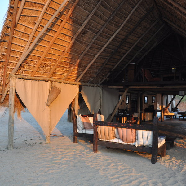
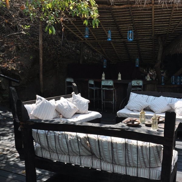
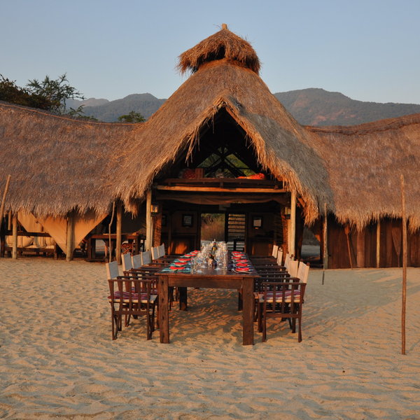
The high-roofed main lodge stands in the centre of the beach, and is completely open sided, allowing the breeze in, and making the most of the verdant views. It houses the main dining area, and a small seating area where you can read up on the local birdlife and wildlife, as well as detailed information about the chimpanzees you'll be tracking. Upstairs, there is a relaxation area with board games, a library, and some extremely comfortable beanbags – set right in the peak of the thatch, with a great view across the lake. There is also a very good little camp shop, selling a variety of curios and stylish gifts. Raised up on the rocks on the far corner of the beach there's also a “Sunset" bar, where guests normally gather for drinks before dinner. The views from up here are fantastic and there are a number of secluded seating spots to enjoy the vista in private.
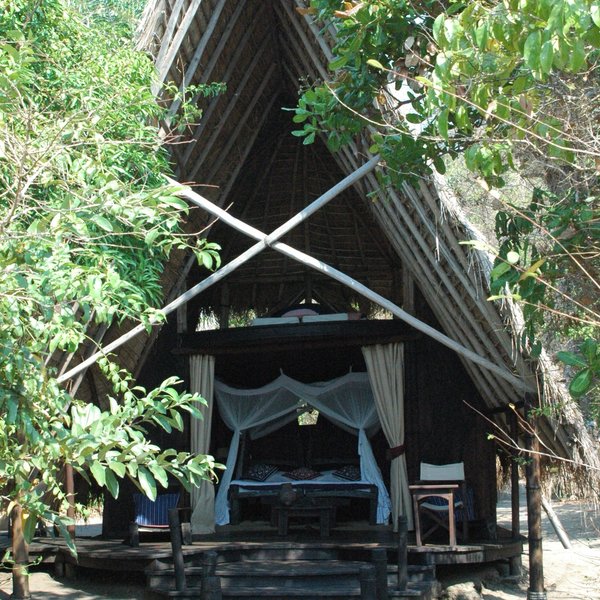
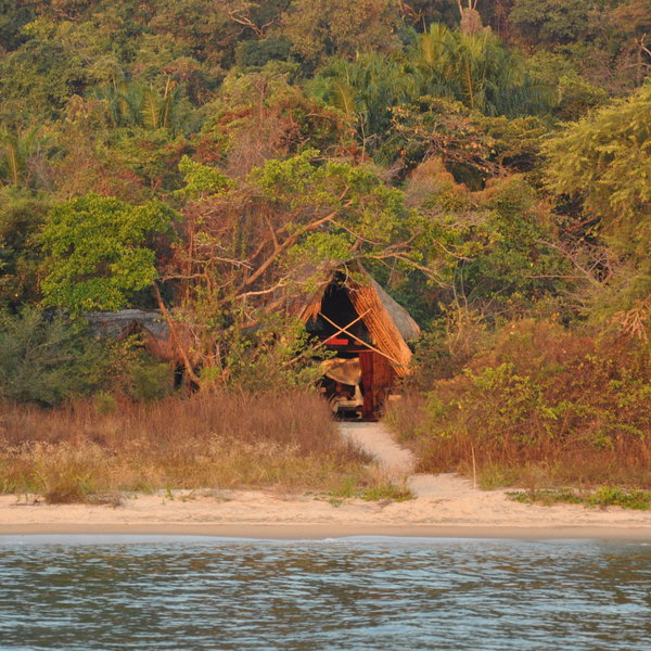
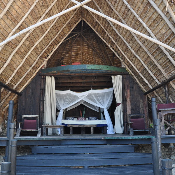
The six bandas at Greystoke Mahale are set further back from the beach and nestled into the vegetation. They're well spaced out with a good degree of privacy, and all face towards the lake (although some of the more private bandas have a slightly less clear view of the lake). Each double-story banda is broadly the same: they're completely open at the front, no doors or zips at all – although there are heavy curtains which can be pulled across and secured to the floor if you want a little more privacy.
The main frame of each banda is made of wooden poles and bamboo blinds, with a tall makuti thatch roof. The large four-poster bed stands in the centre of the room, swathed in a mosquito net. It looks out onto a small decking area, furnished with a couple of sunloungers and a small writing desk.
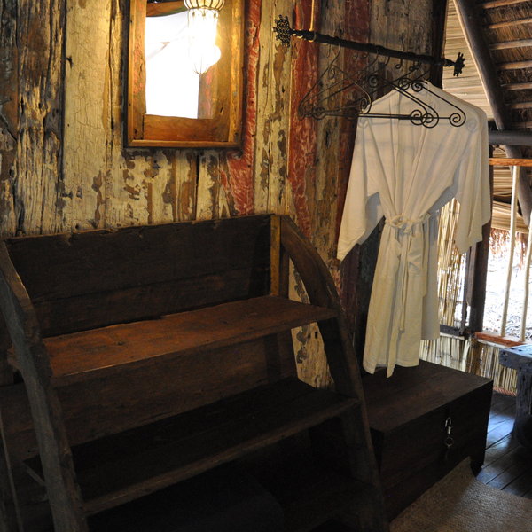
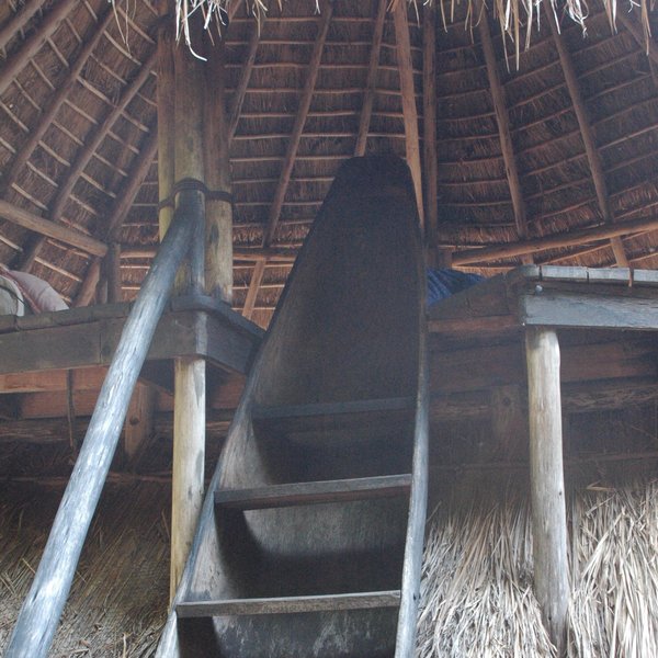
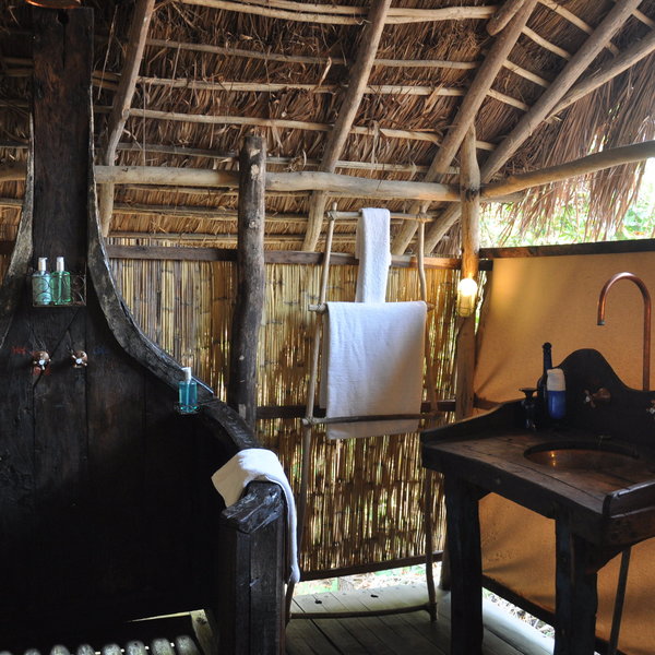
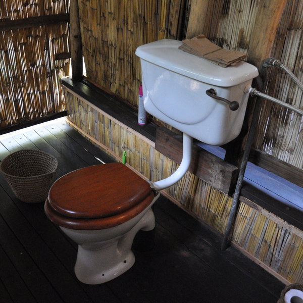
Behind the bed, there's a dressing area with a lockable trunk, some space to hang your clothes and a selection of toiletries. And, at the far back of the banda, is the en-suite bathroom with a flush toilet, shower and sink. Water is heated on demand by individual kerosene burners. Your guide will call ahead at the end of each activity to ensure warm water is ready for you on your return – this usually takes about 15 minutes. The top floor of the banda is reached via a flight of steep stairs carved from an old wooden canoe. Up here there's a day bed to relax on, and in one of the bandas there's also an extra bed for families.
Greystoke Mahale's bandas are spacious and well put together. The majority of the furniture in the room is crafted from old recycled wooden dhow boats salvaged from nearby lakeside villages – the result is a unique, rustic style in tune with its surroundings. Thoughtful touches, such as kikois and towels for the beach, and water bowls to wash the sand off your feet, are very welcome.
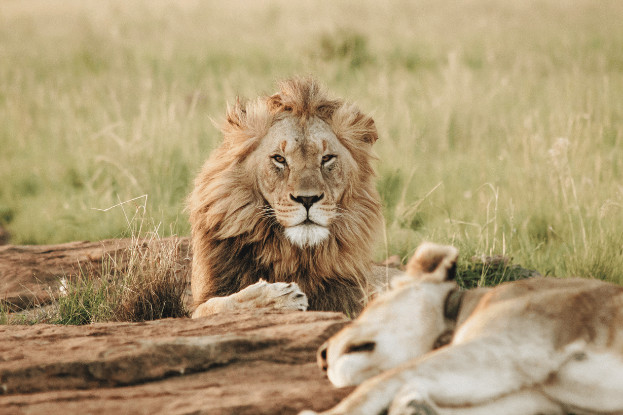
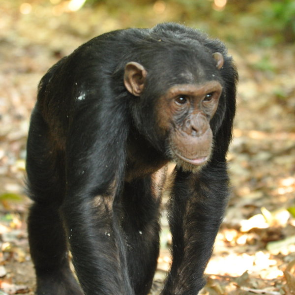
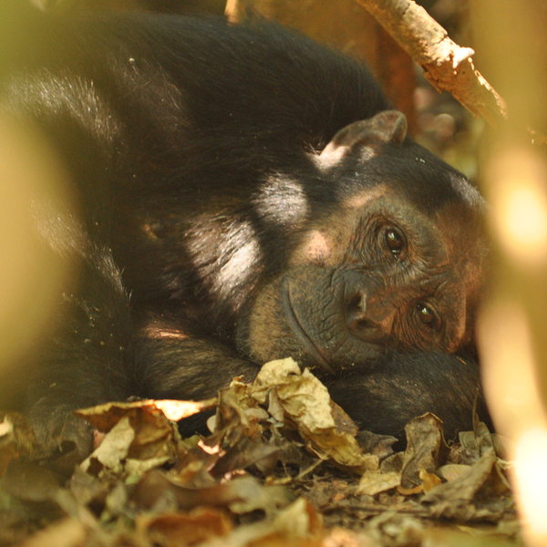
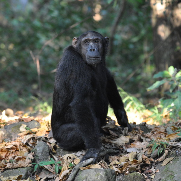
The main activity at Greystoke – and the reason most people come here – is the superb chimp trekking. It's very professionally run and at all times you're accompanied by a park scout and expert guide who know all of the chimps by name, and can explain their behaviour and past history meticulously. This deepens your whole experience beyond simply watching the mammals. For us, it's one of the most riveting wildlife spectacles in Africa. Trekking can take anywhere from a leisurely 20 minutes, to a more strenuous hike of three hours or more. From August to September the chimps tend to be lower down in the mountains – and sometimes in camp! Once you reach the chimps, there is a one hour limit on how long you can spend with them, but if they decide to move on through the forest, the clock stops as you move with them (and try to keep up!) and then restarts when they stop again. The longest guests are permitted to be actively trekking the chimps in proximity is three hours.
There is plenty of other wildlife to see, while searching for the chimps. Birds such as red-capped robin chats, crested guinea fowls, palm nut vultures, harrier hawks and African crowned eagles, as well as the small blue duiker and silver and red colobus monkeys live in the forest. You may come across clay pots left by the BaTongwe tribe, who used to inhabit the area before it was made a national park.
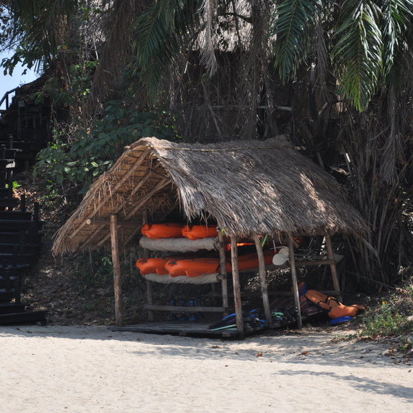
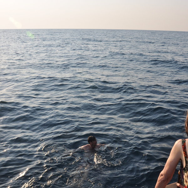
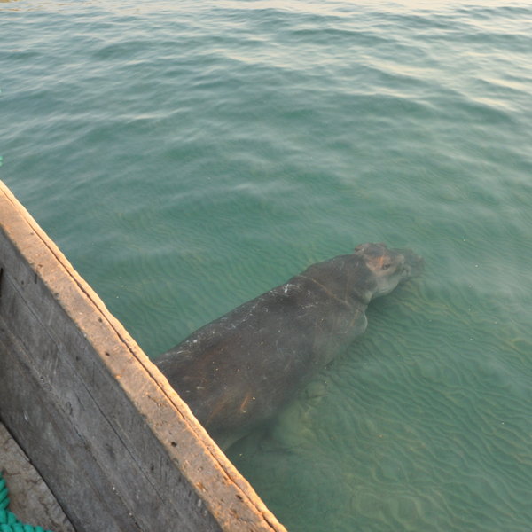
After a morning watching the chimps, spend a lazy afternoon kayaking on the crystal clear waters of Lake Tanganyika, or sailing on a beautiful old dhow. From the boat, you can take a nature cruise along the shore – we were lucky enough to see hippos below in the water! Large crocodiles are occasionally spied lurking in the reeds too. While swimming is not permitted from the shore – due to the occasional crocodile and hippo – the camp will take guests far out into the deep water on the dhow in the afternoons to swim. The water is beautifully warm, crystal clear and fresh, and it's a fantastic experience. Whilst out on the dhow guests are also invited to try their luck at catching one of the many species of tilapia (of which there are many found in the lake), using hand line fishing equipment. In the interests of conservation, only catch and release fishing is permitted.
Activities
Birdwatching
Boat trip
Fishing
Guided walking safari
Kayaking
Primate trekking
Private activities
Families & children
- Attitude towards children
- The camp welcomes families with older children.
- Property’s age restrictions
- Children have to be aged 12+.
- Special activities & services
- None
- Equipment
- None
- Generally recommended for children
- The Mahale Mountains National Park are remote, difficult to access, and expensive, so we’d only recommend it for families with older children. One of the bandas has an extra bed on the mezzanine floor.
Food & drink
- Usual board basis
- Full Board & Activities
- Food quality
- On our last visit, in September 2018, the food at Greystoke was very good indeed – fresh, varied and plentiful. Meals are normally taken communally in the main lodge seated around one long table. Here's an example of what to expect at mealtimes:
Breakfast is usually served around 7.30am. There's a buffet selection of cereal with yoghurt and fresh fruit. The waiters will then come around and take your order for a cooked breakfast – including eggs, bacon and sausages. While you're eating breakfast the guides will be communicating with the trackers as to the location of the chimps. Once they've found them you'll all set off. Be prepared to abandon your breakfast at a moment's notice!
Lunch is usually a light buffet selection. We had dishes such as pizza, roasted aubergines, tomato and cucumber salad, and watermelon and feta salad. A light dessert is then served to your table. There was always a really good choice of dishes, and they were all very tasty.
At about 7.00pm it's usual for guests to gather in the sunset bar for a pre-dinner drink. The waiters bring out some nibbles, and then everyone will then gather around the dining table for a three-course dinner. Starters are usually light; we enjoyed a cucumber, salami and tomato salad. We had pilau rice, Thai chicken curry, pumpkin and fresh vegetables. For dessert we were served an excellent chocolate-and-cashew nut cake. - Dining style
- Mixture of group dining and individual tables
- Dining locations
- Indoor and Outdoor Dining
- Further dining info, including room service
- Private dining and room service is possible.
- Drinks included
- Most drinks are included except premium wines and spirits.
Our travellers’ wildlife sightings from Greystoke Mahale
Since mid-2018, many of our travellers who stayed at Greystoke Mahale have kindly recorded their wildlife sightings and shared them with us. The results are below. Click an animal to see more, and here to see more on our methodology.

100% success

60% success

0% success

0% success

0% success

0% success

0% success

0% success

0% success

0% success

0% success

0% success

0% success

0% success

0% success

0% success

0% success

0% success
Getting there
- Location
- Mahale Mountains National Park, Tanzania
- Ideal length of stay
- There are two flights a week into Mahale (Monday and Thursdays), so three- or four-night stays are usually required.
- Directions
- Mahale is about a five-hour flight from Arusha. From the airstrip, Greystoke is reached via a roughly one-hour boat ride in the camp’s old dhow.
- Accessible by
- Fly-and-Transfer
Special interests
- Honeymoons
- Greystoke Mahale is one of Africa's most original and spectacular places for a honeymoon. The bandas are private and rustic, but with plenty of luxurious touches to make your stay comfortable, and the food and service are top-notch. Perfect for a romantic Tanzania honeymoon.
- See ideas for Honeymoons in Tanzania
- Beach holidays
- Greystoke’s spectacular white beach of fine powder-sand is not beside the ocean, but deep inland, next to the great Lake Tanganyika. So whilst chimp-tracking in Mahale, pause to enjoy a superb beach holiday right in the heart of Africa.
- See ideas for Beach holidays in Tanzania
- Photography safaris
- To include chimpanzees in a photographic holiday in Tanzania, come to Mahale: probably Africa's best location for photographing wild chimps. The scenery is spectacular: a white sand beach separating the blue lake from the tropical, forested mountains.
- See ideas for Photography safaris in Tanzania
- Cultural Experiences
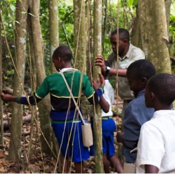
- Guests can visit the local village and school with a member of staff from Greystoke Mahale.
- See ideas for Cultural Experiences in Tanzania
- Wildlife safaris
- Simply the best place for watching chimps and other primates in the forests of central Africa.
- See ideas for Wildlife safaris in Tanzania
- Luxury safaris
- Perfectly placed at the edge of a lush forest, the open-fronted rooms at Greystoke Mahale have unrivalled views of the white sandy beach and the lake beyond. From exclusive chimp tracking to eating sushi on a dhow – experiences at this luxurious lodge are as unique as its setting.
- See ideas for Luxury safaris in Tanzania
Sustainability
Katumbi Clinic and Primary School
Greystoke Mahale works closely with the Katumbi Clinic and the Katumbi Primary School, supporting initiatives concerning the health and education of the local community. Support to the NGO Pencils for Hope is also offered and a variety of programs are run - including meal provision, as well as renovation projects aimed to improve the offerings of the school and clinic.
Guests can visit Katumbi, a relaxing 90-minute boat ride away, where they can learn about and contribute to the initiatives of Nomad and Pencils for Hope. At Katumbi, visitors can learn about some of the vital projects underway, such as the creation of a solar-powered computer lab to aid in community education efforts.
In constructing Greystoke Mahale, its environmental footprint was sensibly considered from stage one of the camp’s design. The rooms are constructed almost entirely of sustainable materials sourced from Lake Tanganyika, which the lodge sits by. These materials, such as reclaimed wood, are the result of transforming old fisherman’s canoes into ladders, or thatch from palm trees for the roofs.
Greystoke Mahale’s projects can be directly supported by donations to the Nomad Trust, as well as through donation of school supplies, medical supplies, and other general living supplies to Pack for a Purpose.
See more great sustainability projects in Tanzania
Communications
- Power supply notes
- They have a backup generator for 24 hour power in the rooms. Battery charging can only be done in the main areas.
- Communications
- There is no WiFi or cellphone reception in Mahale.
- TV & radio
- No
Health & safety
- Malarial protection recommended
- Yes
- Medical care
- There is a first-aid kit on site and the lodge has links with flying doctors.
- Dangerous animals
- Moderate Risk
- Security measures
- You’re escorted to and from your room in the evenings.
- Fire safety
- There are fire buckets in the rooms.
Useful info
- Disabled access
- Not Possible
- Laundry facilities
- Laundry is included. It is hand washed, line dried and coal ironed and usually returned to you within 24 hours. However, like most camps in Tanzania, women’s underwear is not accepted.
- Money
- Each banda has a trunk which can be locked.
- Accepted payment on location
- Cash is recommended to settle any extras and they will accept US$, GB£, Euros and Tanzanian shillings.
Plan and book your trip with Expert Africa
All of our trips are tailor-made, so we'll always adapt them to suit you. Talk to an Expert and let us plan and arrange your perfect trip.

Talk to an Expert
Call or email us now! We’ll match you with the Specialist in our team who is best suited to help you. Then together we can start planning your trip.

Set up your itinerary
Based on our experience and your ideas, your specialist will create a detailed, costed itinerary. We’ll refine it together, until we have a trip that you’re perfectly happy with.

Prepare for your trip
The same Specialist will make the seamless arrangements for your trip, send you detailed travel documents, and be available to answer any questions before you depart.

Travel with peace of mind
After you set off, you’ll be cared for by our partners in Africa, most of whom have worked with Expert Africa for decades. And if you ever need us urgently, we’re available 24/7.

When you return
We love to learn about your trip, and so will always be grateful if you’ve the time to give feedback to your Specialist when you return.
Greystoke Mahale's location
Look closer at the environment and surroundings of Greystoke Mahale.
Other lodges in Mahale Mountains National Park
Alternative places to stay in this same area.
Mbali Mbali Mahale
Mbali Mbali Mahale is a smart lodge on the shores of Lake Tanganyika, primarily visited by travellers keen to meet habituated chimpanzees.
When to go to Mahale Mountains National Park
Our month by month guide: What it's like to visit Greystoke Mahale in Mahale Mountains National Park
Jan
Feb
Mar
Apr
May
Jun
Jul
Aug
Sep
Oct
Nov
Dec
Mahale Mountains National Park in January
Rain is likely in January in the Mahale Mountains National Park, and the chimpanzees disperse into smaller groups to ensure there is plenty of food for all. While wildlife viewing is generally good, some animals may still be dispersed due to lingering moisture from the previous wet season.
Birdwatching is excellent during January, with resident birds in breeding plumage and migrant species present. Forest walks are pleasant, with reduced humidity making for comfortable hikes. Mount Nkungwe trails are more manageable, though some areas may be slippery. The lakeshore of Lake Tanganyika provides a lovely backdrop for activities like kayaking and fishing.
- Variable weather with rain likely
- Good time for birding with migrant species
- Chimpanzee trekking conditions fair
- Lake activities enjoyable in warm weather
Our view
A good time to visit, with pros & cons
Weather in January
Mahale Mountains National Park in February
February is a more challenging time for chimp trekking as the chimpanzees have moved to higher ground and thicker forest looking for food. Rain showers are possible.
Birdwatching remains rewarding, with northern hemisphere migrants joining resident species. The park's hidden waterfalls are more accessible now, providing refreshing stops during guided forest walks. Mount Nkungwe hikes offer panoramic views of the park and lake, though early starts are recommended to avoid midday heat.
- Challenging time for chimpanzee trekking
- Birdwatching opportunities abundant
Our view
A good time to visit, with pros & cons
Weather in February
Mahale Mountains National Park in March
March marks the beginning of the long rainy season in Mahale Mountains National Park. Chimpanzee trekking continues to be challenging as the apes move to higher elevations. Camps may be closed – speak to us for more details. However, this is an excellent time for botanists and butterfly enthusiasts, as the forest bursts into bloom. The park's diverse flora, including unique species in the Kasoge forest, is at its most vibrant. Birdwatching remains rewarding, especially for forest species.
While some trails become muddy, experienced guides can still lead exciting forest walks, showcasing the park's lush vegetation and smaller wildlife. Mount Nkungwe hikes are not recommended due to slippery conditions. Lake Tanganyika's water levels rise, changing the shoreline landscape.
- Increasing humidity as rainy season starts
- Chimpanzee sightings challenging
- Migratory birds start to depart
- Lush greenery enhances forest walks
- Camps may be closed
Our view
A good time to visit, with pros & cons
Weather in March
Mahale Mountains National Park in April
The rains continue into April, and camps remain closed. The dense vegetation and often slippery trails makes wildlife spotting more challenging, but patient observers can witness fascinating behaviours. Chimpanzees construct leafy nests for shelter, visible from a distance. The park's rivers and streams swell, creating temporary waterfalls and rapids. This is an excellent time for photography enthusiasts to capture the lush, green landscapes and moody atmospheres.
Birdwatching remains rewarding, especially for forest-dwelling species. Lake Tanganyika's shoreline activities are limited, but the lake itself is a spectacle with dramatic skies and occasional storms.
- Heavy rains may impact park accessibility
- Chimpanzee trekking difficult due to weather
- Waterfalls and streams at their most impressive
- Birdwatching good for resident species
- Limited lake activities due to weather
Our view
This is not a great time to visit
Weather in April
Mahale Mountains National Park in May
As May progresses, the long rains in Mahale Mountains National Park begin to taper off, and lodges re-open towards the end of the month. The landscape is lush and green, with rivers and streams still flowing strongly. Visitors should still expect challenging chimpanzee trekking conditions. The forest is dense with the vegetation and at its most vibrant and many plants in fruit.
Birdwatching is excellent, especially for forest species and water birds around the swollen lakes and rivers. Lake Tanganyika's water levels are high, altering the shoreline landscape. As the rains decrease, hiking trails to Mount Nkungwe become more accessible, offering stunning views of the verdant park.
- Rains begin to subside towards end of month
- Chimpanzee trekking conditions remain challenging
- Hiking trails start to dry out
- Lush and dense vegetation
Our view
This is not a great time to visit
Weather in May
Mahale Mountains National Park in June
June marks the transition to the dry season in Mahale Mountains National Park. Chimpanzee trekking conditions begin to improve significantly but the chimps are mostly still high up in the forest taking advantage of the abundance of food. The forest starts to dry out, making walking trails more accessible. This is an excellent time for hiking to Mount Nkungwe, offering panoramic views of the park and Lake Tanganyika.
The lake's water levels begin to recede, revealing sandy beaches perfect for relaxation after activities. Afternoon swims are possible in deeper water.
- Dry season begins
- Chimpanzee trekking improves but chimps remain on higher ground
- Hiking to Mount Nkungwe becomes favourable
- Possible to swim in the deeper waters of Lake Tanganyika
- Birdwatching excellent as skies clear
Our view
A good time to visit, with pros & cons
Weather in June
Mahale Mountains National Park in July
July is the start of the peak season in Mahale Mountains National Park. Chimpanzee trekking starts to become a little easier as the month progresses and the chimps begin to descend from their higher reaches. The dry weather makes forest trails more easily navigable, ideal for guided walks and wildlife spotting. Lake Tanganyika's waters are calm and clear, perfect swimming in deeper waters.
Birdwatching is excellent, especially around the lakeshore and in the miombo woodlands. Mount Nkungwe hikes offer breathtaking views in the crisp air. The dry conditions draw various animals to water sources, increasing wildlife sighting opportunities.
- Improving conditions for hiking and forest walks
- Clear skies perfect for stargazing
- Wildlife more visible near water sources
Our view
A very good time to visit
Weather in July
Mahale Mountains National Park in August
August is one of the hotter months in Mahale Mountains National Park. The dry weather continues, with clear skies and sunny days. Chimpanzee trekking reaches its peak, with frequent and prolonged sightings as the apes spend more time in accessible areas. The low vegetation improves visibility for other wildlife spotting during guided forest walks.
Lake Tanganyika's shores are perfect for relaxation and cooling swims in the deeper waters. Birdwatching remains excellent, with many species congregating around remaining water sources. Mount Nkungwe hikes are highly rewarding, offering panoramic views of the park and lake. The dry conditions make this an ideal time for overnight camping experiences in the park, allowing for immersive nature encounters and spectacular stargazing opportunities.
- Excellent weather for all park activities
- Chimpanzee sightings frequent and rewarding
- Mount Nkungwe hike offers spectacular views
- Lake activities continue to be enjoyable
Our view
Fantastic: the very best time to visit
Weather in August
Mahale Mountains National Park in September
September is an excellent month to visit Mahale Mountains National Park. Chimpanzee trekking remains outstanding, with high chances of extended observations. The low vegetation improves visibility during guided forest walks, increasing opportunities to spot other primates and smaller mammals. Lake Tanganyika's shores are perfect for relaxation and cooling swims in the deeper waters.
Birdwatching is rewarding, especially around the lakeshore and remaining water sources. Mount Nkungwe hikes offer stunning vistas in the clear air.
- Dry season continues with ideal conditions
- Chimpanzee trekking remains a highlight
- Lake Tanganyika waters clear for activities
- Birdwatching excellent with clear visibility
Our view
Fantastic: the very best time to visit
Weather in September
Mahale Mountains National Park in October
October sees the dry season drawing to a close. Chimpanzee trekking remains excellent, with the apes often seen near the lakeshore. The park's landscape is at its driest, making wildlife easier to spot as animals congregate around remaining water sources. Lake Tanganyika's water levels are at their lowest, revealing expansive beaches.
This is a great time for water activities and beach relaxation. Birdwatching is productive, with many species gathering near the lake. Mount Nkungwe hikes offer panoramic views, though the ascent can be hot. Guided forest walks provide opportunities to see a variety of wildlife in the open vegetation.
- Last month of peak chimpanzee trekking season
- Warm days perfect for lake activities
- Hiking trails dry and easily accessible
- Wildlife concentrated around water sources
Our view
A very good time to visit
Weather in October
Mahale Mountains National Park in November
November sees the start of the rains again in Mahale Mountains National Park. The landscape begins to transform as vegetation responds to the moisture. The rain showers create dramatic scenes over Lake Tanganyika, perfect for photography. Birdwatching is excellent as migrants arrive and many species don their breeding plumage. The forest comes alive with new growth, making guided walks particularly interesting for botany enthusiasts. Chimpanzee trekking remains good, with the chimps typically remaining on the lower slopes.
Mount Nkungwe hikes become more challenging but offer some intriguing misty vistas. The park's waterfalls begin to flow more vigorously, creating picturesque scenes.
- Rains likely, increasing humidity
- Chimpanzee trekking still good
- Migratory birds start to return to the park
- Lake activities may be affected by weather
- Lush scenery returns as vegetation grows
Our view
A good time to visit, with pros & cons
Weather in November
Mahale Mountains National Park in December
December in Mahale Mountains National Park is characterised by the short, dramatic rain storms. Despite intermittent showers, many activities remain enjoyable. Chimpanzee trekking continues, though the apes are often found at higher elevations from more challenging trails. The rejuvenated vegetation makes for lush, green landscapes, ideal for photography.
Birdwatching is excellent, with many species in breeding plumage and migratory birds present. Guided forest walks showcase the park's flora in full bloom. Mount Nkungwe hikes are challenging due to slippery conditions, but lower elevation trails remain accessible. The rain brings relief from the heat, and afternoon showers often give way to beautiful sunsets over the lake. December offers a unique, very quiet experience of Mahale.
- Variable weather with occasional rain
- Chimpanzee trekking conditions tricky
- Lake activities possible on clear days
- Birdwatching good as migrant species return
Our view
A good time to visit, with pros & cons
Weather in December

Looking for inspiration on where to travel next?
Visit our trip chooser to explore your options and find inspiration for your perfect African adventure
Inspire me